
Science & Technology
May 2, 2016 · 11 comments


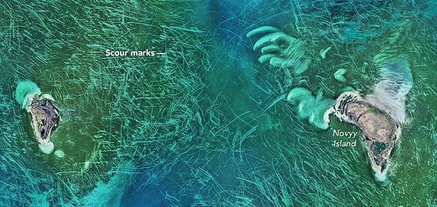
The image focuses on the area around Novyy Island. Image Credit: NASA / Norman Kuring
Captured using the Operational Land Imager on the Landsat 8 satellite, the photograph shows an area of the Caspian Sea that looks like it has been scoured using a Brillo Pad.
The answer, as it turns out, is a process known as ice gouging.
The water in this region of the Caspian Sea is actually very shallow - only around 10ft deep - and sea ice on the surface is also relatively thin at around 1.6ft thick.
Over time the winds and ocean currents can sculpt this ice in to jagged patterns known as hummocks which can sometimes reach as far as the seabed.
When the wind blows this floating ice around on the surface, the protruding parts underneath can drag along the ocean floor and create the line patterns seen in the satellite image.
Source: Live Science | Comments (11)
Mysterious lines show up in the Caspian Sea
By T.K. RandallMay 2, 2016 ·
11 comments
The image focuses on the area around Novyy Island. Image Credit: NASA / Norman Kuring
A chaotic pattern of scour marks in the Tyuleniy Archipelago has been photographed by a NASA satellite.
First noticed by scientists at NASA's Goddard Space Flight Center last month, the peculiar lines criss-crossing the world's largest inland body of water have proven rather perplexing.Captured using the Operational Land Imager on the Landsat 8 satellite, the photograph shows an area of the Caspian Sea that looks like it has been scoured using a Brillo Pad.
#SciFri puzzler in @NASA_Landsat @USGSLandsat #Caspian image: what causes lines near TyuleniyArchipelago? Trawling? pic.twitter.com/s83h6UP03c
— NASA Oceans (@NASAOceans) April 8, 2016
The answer, as it turns out, is a process known as ice gouging.
Over time the winds and ocean currents can sculpt this ice in to jagged patterns known as hummocks which can sometimes reach as far as the seabed.
When the wind blows this floating ice around on the surface, the protruding parts underneath can drag along the ocean floor and create the line patterns seen in the satellite image.
Source: Live Science | Comments (11)


The Unexplained Mysteries
Book of Weird News
AVAILABLE NOW
Take a walk on the weird side with this compilation of some of the weirdest stories ever to grace the pages of a newspaper.
Click here to learn more
Support us on Patreon
BONUS CONTENTFor less than the cost of a cup of coffee, you can gain access to a wide range of exclusive perks including our popular 'Lost Ghost Stories' series.
Click here to learn more
Science and Technology

Spirituality, Religion and Beliefs
United States and the Americas
UK and Europe
Total Posts: 7,752,449 Topics: 324,072 Members: 203,520
Not a member yet ? Click here to join - registration is free and only takes a moment!
Not a member yet ? Click here to join - registration is free and only takes a moment!
1 week
2 weeks
3 weeks
1 month


This week
This month
All time
| 1. | Loch Ness Monster | |
| 2. | Bigfoot | |
| 3. | Electronic Voice Phenomenon | |
| 4. | Spirit Photography (Classic) | |
| 5. | Pareidolia | |
| - | 6. | Paranormal |
| 7. | Roswell Incident | |
| 8. | Orb | |
| 9. | Unidentified Flying Object | |
| 10. | Extraterrestrial |


Top | Home | Forum
News | Columns | Encyclopedia


UM 11.2 Unexplained-Mysteries.com (c) 2001-2025
Terms | Privacy Policy | Cookies | Contact
News | Columns | Encyclopedia
UM 11.2 Unexplained-Mysteries.com (c) 2001-2025
Terms | Privacy Policy | Cookies | Contact
Please Login or Register to post a comment.