Saturday, October 12, 2024
Contact    |    RSS icon Twitter icon Facebook icon  
Unexplained Mysteries
You are viewing: Home > News > Nature & Environment > News story
Welcome Guest ( Login or Register )  
All ▾
Search Submit

Nature & Environment

Massive canyon found under Antarctic ice

By T.K. Randall
January 18, 2014 · Comment icon 24 comments

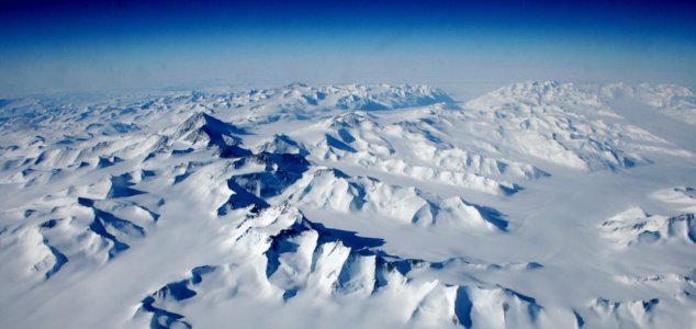
Researchers have been studying the subglacial terrain of Antarctica. Image Credit: CC BY-SA 2.0 Eli Duke
A huge subglacial trench deeper than the Grand Canyon has been discovered hidden beneath the Antarctic.
The discovery was made by a team of scientists who had been charting an ancient mountain range located deep below the ice known as the Ellsworth Subglacial Highlands.

Using a combination of ground-penetrating radar and satellite imagery they were able to build up a picture of the continent's long lost topography.
The giant trench is believed to go down over 1.9 miles which makes it deeper than the Grand Canyon's 1.13 miles. It is thought that this new Antarctic canyon was initially formed by an ancient river running through a geological fault, then widened over the years by glaciation.

"It's a huge privilege to be able to reveal another piece of the jigsaw puzzle that is the surface of our Earth," said geophysicist Neil Ross who lead the study team.

Source: National Geographic | Comments (24)


Other news and articles
Recent comments on this story
Comment icon #15 Posted by Doug1029 11 years ago
I think you may be referring to the Piri Reis map? I seem to recall that this map showed (part of) Antarctica as it would appear ice-free. Not sure if that's right through. Antartica was once a lot farther north, but acquired its current position through continental drift. The continent ice over about 15 to 12 mya when the Straits of Panama closed and rerouted global ocean circulation. The Piri Reis maps show the coast of Antarctica, but also show non-existent islands and are missing a few islands that are actually there. This tends to argue against the view-from-space idea and the help of lit... [More]
Comment icon #16 Posted by avs76 11 years ago
Could the missing islands be explained by the possibility that the sea levels may heve been different at the time the map was made? Just a thought.
Comment icon #17 Posted by Peter B 11 years ago
Could the missing islands be explained by the possibility that the sea levels may heve been different at the time the map was made? Just a thought. Very unlikely. The map is impressively accurate in showing what was known by European sailors by around 1515: it shows the Caribbean, the northern part of South America, Africa and Spain very well. Beyond that it gets really wobbly. For example South America curves around into "Antarctica" way too far north - seemingly just south of the Plate River estuary. Another problem with it showing Antarctica is that notes in that part of the map apparently ... [More]
Comment icon #18 Posted by Noteverythingisaconspiracy 11 years ago
I never really got why people are so amazed by the Piri Reis map. Like Peter B said, Europe and the Carribean and the eastern parts of Brazil are fairly accurate, but the rest of South America is basically made up, and so is North and Central America. If this is a depiction of antarctica where is the Strait of Magellan ? Seems like a very significant omission. And it shows people with faces in their stomach
Comment icon #19 Posted by Doug1029 11 years ago
Could the missing islands be explained by the possibility that the sea levels may heve been different at the time the map was made? Just a thought. Piri died in 1553. Sea levels were a little lower then, but not much. Doug
Comment icon #20 Posted by Doug1029 11 years ago
If this is a depiction of antarctica where is the Strait of Magellan ? Seems like a very significant omission. The maps are believed to date from about 1515. Magellan didn't discover the Straits of Magellan until 1520. Doug
Comment icon #21 Posted by Noteverythingisaconspiracy 11 years ago
The maps are believed to date from about 1515. Magellan didn't discover the Straits of Magellan until 1520. Doug That doesent change the fact that it was still there. You cant have an accurate map of Antarctica without a strait betweeen it and South America.
Comment icon #22 Posted by Doug1029 11 years ago
That doesent change the fact that it was still there. You cant have an accurate map of Antarctica without a strait betweeen it and South America. It's sort of hard to map something you don't know is there. Doug
Comment icon #23 Posted by The Silver Thong 11 years ago
I thought the op said A Massive Canon......
Comment icon #24 Posted by Noteverythingisaconspiracy 11 years ago
It's sort of hard to map something you don't know is there. Doug I know the Magellan Strait wasnt discovered yet in the time of Piri Reis, and my point is that it only shows accurately what was known at the time, the rest is guess work. What i meant was, if someone supposedly knew how Antartica looked witout ice, wouldnt they also have know about the strait between Antartica and South America ?


Please Login or Register to post a comment.


Our new book is out now!
Book cover

The Unexplained Mysteries
Book of Weird News

 AVAILABLE NOW 

Take a walk on the weird side with this compilation of some of the weirdest stories ever to grace the pages of a newspaper.

Click here to learn more

We need your help!
Patreon logo

Support us on Patreon

 BONUS CONTENT 

For less than the cost of a cup of coffee, you can gain access to a wide range of exclusive perks including our popular 'Lost Ghost Stories' series.

Click here to learn more

Recent news and articles