Science & Technology
June 28, 2020 · 4 comments
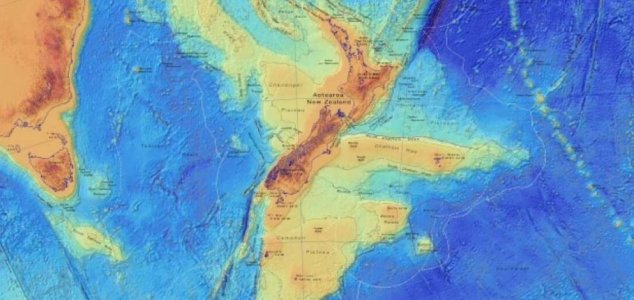
New Zealand is one small part of what was once a large continent. Image Credit: GNS Science
Nowadays New Zealand is pretty much all that's left of this once enormous landmass, however thanks to modern satellite imaging techniques it has finally become possible to begin slowly unraveling the shape and scale of this genuine 'lost world' for the first time.
Now the team behind GNS Science - a New Zealand-based research group - has released a number of highly-detailed new maps showing the hidden continent in all its glory.
"We've made these maps to provide an accurate, complete and up-to-date picture of the geology of the New Zealand and southwest Pacific area - better than we have had before," said geologist Nick Mortimer. "Their value is that they provide a fresh context in which to explain and understand the setting of New Zealand's volcanoes, plate boundary and sedimentary basins."
Perhaps the most intriguing of the new maps is the bathymetric map (pictured above) which shows the shape of the ocean floor and in so doing helps to highlight the sheer scale of Zealandia.
It's incredible to imagine what this long-lost continent may have been like when it was above the water.
You can check out all the maps on the GNS Science site - here.
Source: IFL Science | Comments (4)
Lost continent 'Zealandia' revealed in new maps
By T.K. RandallJune 28, 2020 ·
 4 comments
New Zealand is one small part of what was once a large continent. Image Credit: GNS Science
Geologists have released a series of detailed maps showing a long-lost landmass in the southwest Pacific.
Situated to the east of Australia - Zealandia is an entire continent of five million square kilometers that sank beneath the waves between 60 and 85 million years ago.Nowadays New Zealand is pretty much all that's left of this once enormous landmass, however thanks to modern satellite imaging techniques it has finally become possible to begin slowly unraveling the shape and scale of this genuine 'lost world' for the first time.
Now the team behind GNS Science - a New Zealand-based research group - has released a number of highly-detailed new maps showing the hidden continent in all its glory.
Perhaps the most intriguing of the new maps is the bathymetric map (pictured above) which shows the shape of the ocean floor and in so doing helps to highlight the sheer scale of Zealandia.
It's incredible to imagine what this long-lost continent may have been like when it was above the water.
You can check out all the maps on the GNS Science site - here.
Source: IFL Science | Comments (4)

The Unexplained Mysteries
Book of Weird News
AVAILABLE NOW
Take a walk on the weird side with this compilation of some of the weirdest stories ever to grace the pages of a newspaper.
Click here to learn more

Support us on Patreon
BONUS CONTENTFor less than the cost of a cup of coffee, you can gain access to a wide range of exclusive perks including our popular 'Lost Ghost Stories' series.
Click here to learn more
United States and the Americas
Natural World
Space: Astronomy and Astrophysics
Russia and the War in Ukraine
Total Posts: 7,767,998 Topics: 325,013 Members: 203,758
Not a member yet ? Click here to join - registration is free and only takes a moment!
Not a member yet ? Click here to join - registration is free and only takes a moment!









Please Login or Register to post a comment.