Science & Technology
November 11, 2018 · 13 comments

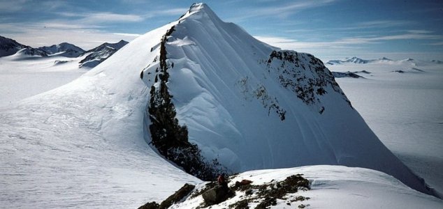
What lies hidden beneath the Antarctic ice ? Image Credit: CC BY-SA 2.0 euphro
While the satellite mission itself ended in 2013, the data it collected is still proving invaluable.
Antarctica was once part of a much larger supercontinent known as Gondwana which began to break apart sometime around 130 million years ago.
By combining the satellite data with seismological data, scientists have been able to map out hidden geological features in the Earth's lithosphere - the outer shell consisting of the crust and mantle.
This has, in turn, helped to highlight the terrain beneath the ice and how it evolved over time.
"In East Antarctica we see an exciting mosaic of geological features that reveal fundamental similarities and differences between the crust beneath Antarctica and other continents it was joined to," said team member Fausto Ferraccioli from the British Antarctic Survey.
A 3D recreation showing how Antarctica's plate tectonics have changed over the last 200 million years can be viewed below.
Source: Science Alert | Comments (13)
Relics of lost continents found under Antarctica
By T.K. RandallNovember 11, 2018 ·
 13 comments
What lies hidden beneath the Antarctic ice ? Image Credit: CC BY-SA 2.0 euphro
Scientists have used satellite data to map out the terrain hidden beneath the ice of the southernmost continent.
The study used data from the Gravity Field and Steady-State Ocean Circulation Explorer (GOCE) satellite which precisely measured the pull of Earth's gravity to map out hidden landmasses.While the satellite mission itself ended in 2013, the data it collected is still proving invaluable.
Antarctica was once part of a much larger supercontinent known as Gondwana which began to break apart sometime around 130 million years ago.
This has, in turn, helped to highlight the terrain beneath the ice and how it evolved over time.
"In East Antarctica we see an exciting mosaic of geological features that reveal fundamental similarities and differences between the crust beneath Antarctica and other continents it was joined to," said team member Fausto Ferraccioli from the British Antarctic Survey.
A 3D recreation showing how Antarctica's plate tectonics have changed over the last 200 million years can be viewed below.
Source: Science Alert | Comments (13)

The Unexplained Mysteries
Book of Weird News
AVAILABLE NOW
Take a walk on the weird side with this compilation of some of the weirdest stories ever to grace the pages of a newspaper.
Click here to learn more

Support us on Patreon
BONUS CONTENTFor less than the cost of a cup of coffee, you can gain access to a wide range of exclusive perks including our popular 'Lost Ghost Stories' series.
Click here to learn more
Extraterrestrial Life and The UFO Phenomenon
Natural World
Ancient Mysteries and Alternative History
Cryptozoology, Myths and Legends
Total Posts: 7,755,373 Topics: 324,263 Members: 203,564
Not a member yet ? Click here to join - registration is free and only takes a moment!
Not a member yet ? Click here to join - registration is free and only takes a moment!


Please Login or Register to post a comment.